Community Profiles
Municipal Districts and Counties
Cardston County - www.cardstoncounty.com
Quick Facts
- Land area (square km): 3,415
- Population (2016): 4,481
- Growth since 2011: 7.5%
- Average House Price (2012): $265,389.00; Rural Area Average: $494,000.00
- Median age of the population (2011): 37.4
- % of the population aged 15 and over (2011): 76.7
- Number of Businesses: 68 licensed business in CFABSW region in 2012
- Major Employers: Westwind School Division, Temple City Housing, Town of Cardston, Cardston County
- Labour force: 2,205 persons*
- Employment: 2,135 persons*
- Unemployment: 70 persons*
- Participation rate (%): 72.5*
- Unemployment rate (%): 3.2*
- Employment rate (%): 70.2*
- Municipal Land for Development for sale: Contact the County office at 403-653-4977.
- Municipal Investment Incentives: Contact the County office at 403-653-4977.
- Key Economic Sectors: Agriculture, Tourism, Wind Energy
- Trading Area: 42,000+ residents within its 100 kilometre Trading Area (extended trading area reaches into Lethbridge and south into Montana)
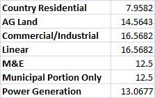
- Mill Rates:
- Transportation: Cardston Municipal Airport has all-weather facilities and a 1,064 metre runway. Only private or charter flights are available, no commercial flights. The nearest commercial and air freight services are at Lethbridge; Major Highways include the #2 running north and south, providing easy access to Lethbridge via the # 3 and Calgary and Edmonton to the north. Highway #62 is a north/south route that provides access to Del Bonita and the Del Bonita Border Crossing. Highway 5 runs through the Town of Cardston and is the western route to Waterton National Park and Going to the Run Road to Glacier National Park in Montana. Two other ports of to the United States include one at Carway and another at Chief Mountain.
- Utilities: County supplies water through private wells or local water co-ops. Spring Coulee water plant provides water to many residents; Garbage, landfill and recycling sites are located throughout the County; Electrical – Enmax, Epcor; Natural Gas - Chief Mountain Natural Gas Co-op, Direct Energy; Telecommunications - Telus
- Average Daily Temperature (January): -6 C
- Average Daily Temperature (July): 18 C
- Time Zone: Mountain Time (-7 UTC)
* 2006 Census - 2011 data suppressed for data quality or confidentiality.
MD of Pincher Creek - www.mdpinchercreek.ab.ca
Quick Facts
- Land Area: 3,482 km²
- Population (2016): 2,965
- Growth since 2011: -6.1%
- Average House Price (2012): $289,113.00; Rural Area Average: $445,488.00
- Median age of the population (2011): 46.9
- % of the population aged 15 and over (2011): 83.5
- Number of Businesses: 58 licensed businesses in 2012
- Major Employers: MD of Pincher Creek, Town of Pincher Creek, Shell Canada Gas Plant
- Labour force: 1730 persons*
- Employment: 1,600 persons*
- Unemployment: 125 persons*
- Participation rate (%): 73.6*
- Unemployment rate (%):7.2*
- Employment rate (%):68.1*
- Key Economic Sectors: Agriculture, Energy, Tourism
- Trading Area: 47,500+ residents within its 100 kilometre Trading Area (extended trading area reaches into Crowsnest Pass, the BC interior, Lethbridge and south into Montana)
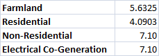
- Mill Rates:
- Transportation: Canadian Pacific Railways freight service; The Pincher Creek Regional Airport is located two miles west & two miles north of Pincher Creek, just south of Highway # 3. It is an asphalt strip 6,597 ft. or 2,011 m. in length; Daily Greyhound service from Pincher Creek; The number three highway runs from the Trans-Canada in the east through to British Columbia and the ports on the western coast; Highway number three accesses Highway number two which runs north through to Edmonton and south on the number six to the United States on the Canamex Corridor. Highway 22 runs north south along the western edge of the MD intersecting highway 3 outside of Lundbreck. Several other secondary highways support transportation through the MD.
- Utilities: Municipal waste - Crowsnest/Pincher Creek Landfill Association, rural household waste collection sites, Recycling - Cameron KJ Services Industries Ltd.
- Community Municipal Planning (Zoning and By-Laws): Refer to the Planning and Development page on the municipality website or the Land Use Bylaw -1140-08.
- Average Daily Temperature (January): -9.5 C
- Average Daily Temperature (July): 26 C
- Time Zone: Mountain Time (-7 UTC)
* 2011 National Household Survey.
MD of Willow Creek - www.mdwillowcreek.com
Quick Facts
- Land area (square km): 4,558
- Population (2016): 5,179
- Growth since 2011: 1.4%
- Average House Price (2012): $249,258.00 Rural Area Average: $489,667.00
- Median age of the population (2011): 39.6
- % of the population aged 15 and over (2011): 77.4
- Number of Businesses: 88 licensed business in CFABSW region in 2012
- Major Employers: MD of Willow Creek, Town of Claresholm, Town of Fort Macleod
- Labour force: 3,255 persons*
- Employment: 3,190 persons*
- Unemployment: 65 persons*
- Participation rate (%): 81.5*
- Unemployment rate (%): 2.0*
- Employment rate (%): 79.8*
- Commercial and Industrial Property Available: Contact the MD office at 403-625-3351.
- Municipal Investment Incentives: Contact the MD office at 403-625-3351.
- Key Economic Sectors: Agriculture, Wind Energy.
- Trading Area: 52,000+ residents within its 100 kilometre Trading Area (extended trading area accesses Calgary, Lethbridge and several other communities outside its boundaries).
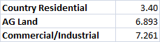
- Mill Rates:
- Transportation: Access to air service through the Claresholm Municipal Airport which handles medium to light aircraft on a 945 metre (3,100 ft.) asphalt strip; Two major highways, the #2 running north/south and the #3 running east west, bisect the MD. There are several well-maintained secondary roads which provide a solid network for travel and transportation.
- Utilities: Contact the MD office at 403-625-3351 for information on utility availability and utility requirements.
- Community Municipal Planning (Zoning and By-Laws): Refer to the development section under departments on the MD website, or download the land use document.
- Average Daily Temperature (January): -8.4 C
- Average Daily Temperature (July): 18.3 C
- Time Zone: Mountain Time (-7 UTC)
* 2006 Census figure - 2011 data suppressed for data quality or confidentiality.
Towns
Cardston - www.cardston.ca
Cardston is located in the foothills of Southwest Alberta and is only minutes away from Waterton National Park. The population of Cardston is 3,580. The town maintains its proud heritage through its several world class tourist attractions, whether it is the Rocky Mountains or the carriage museum.
Quick Facts
- Land area (square km): 8.64
- Population (2016): 3,585
- Growth since 2011: 0.1%
- Average House Price (2012): $263,092.00
- Median age of the population (2011): 38.4
- % of the population aged 15 and over (2011): 75.9
- Number of Businesses: 270 business licences issued in 2012.
- Major Employers: Westwind School Division, Chinook Health Authority, Town of Cardston, Cardston County, Extra Foods
- Labour force: 1,555 persons*
- Employment: 1,520 persons*
- Unemployment: 35 persons*
- Participation rate (%): 62.0*
- Unemployment rate (%): 2.3*
- Employment rate (%): 60.6*
- Industrial and Commercial Business Park: Refer to town website at http://www.cardston.ca/real-estate-and-permits/.
- Trading Area: 15,000 residents within its 100 kilometre Trading Area
- Commercial and Industrial Property Available: Refer to the “Private Land and Town Owned Property for Sale” sections on town website at http://www.cardston.ca/real-estate-and-permits/.
- Mill Rates: Residential – 7.4912 Non-residential – 13.1322
- Cost of commercial and industrial land: Contact the Town office at (403) 653-3366 or private developer.
- Municipal Investment Incentives: Contact the Cardston Economic Development Office at (403) 653-3366 or visit http://www.orrsc.com/members/towns-a-m/town-of-cardston
- Key Economic Sectors: Housing material manufacturing, Agriculture, Oil & Gas Exploration, and Tourism
- Transportation: Cardston Municipal Airport has all-weather facilities and a 1,064 metre (3,500 ft.) asphalt runway. The nearest commercial and air freight services are at Lethbridge; Cardston is accessible by primary provincial highways #2 and #5 which connect to the Canamex Corrider to the south and routes to Calgary and Edmonton to the north. Cardston is also serviced by secondary highway #501.
- Utilities: Municipal, water, sewage, garbage and recycling services; Electrical – Enmax, Natural Gas - ATCO Gas, Chief Mountain Natural Gas Co-op; Telecommunications – Telus, Shaw Cable
- Community Municipal Planning (Zoning and By-Laws): Refer to theLand Use Bylaws & Policies on town website at http://cardston.ca.
- Average Daily Temperature (January): -6 C
- Average Daily Temperature (July): 16.9 C
- Time Zone: Mountain Time (-7 UTC)
* 2006 Census figure - 2011 data suppressed for data quality or confidentiality.
Claresholm - www.townofclaresholm.com
Claresholm is located in the MD of Willow Creek, half way between Calgary and Lethbridge on Highway #2. The population of Claresholm is approximately 3,800. The town rests on the fringe of the spectacular foothills of Alberta, providing easy access to a number of mountain vistas and recreational opportunities.
Quick Facts
- Land area (square km): 2.68
- Population (2016): 3,424
- Growth since 2011: 1.4%
- Average House Price (2012): $238,715.00
- Median age of the population: 51.1
- % of the population aged 15 and over: 86.6
- Number of Businesses: 441 business licences were issued in 2012.
- Major Employers: Calgary Health Region, iLevel, A Weyerhaeuser Company, Livingstone Range School Div. No. 68 Education, Claresholm Centre for Mental Health and Addictions Health Care, Willow Creek Continuing Care Centre, Watt & Stewart Commodities Inc., VJV Foothills Livestock Auction, El Molino Foods of Canada, Triple "T" Trucking Ltd.
- Labour force: 1,750*
- Employment: 1,650*
- Unemployment: 100*
- Participation rate (%): 56.8*
- Unemployment rate (%): 5.7*
- Employment rate (%): 53.6*
- Industrial and Commercial Business Park: Industrial development in Claresholm has been developed in two separate nodes of the community. The southeast quadrant of the community is the original industrial area. The new industrial area of Town is located in the north western area of the community. The industrial area in the northwest portion of the community will deliver industrial business services due to the fact it is adjacent to an existing and growing residential area in Claresholm. As heavy industrial businesses locate in the community, they will be concentrated in the southeast portion of the community where growth is expected. Commercial activity is focused in the downtown area located west of Highway No. 2 located between 51st Avenue, on the north side, and 48th Avenue, on the south, extending west one block off the highway to 2nd Street West. Within the downtown commercial sector, the majority of the retail, office and service outlets are located in this area.
- Trading Area: 13,600 residents within its 100 kilometre Trading Area
- Commercial and Industrial Property Available: Please contact the Town of Claresholm Department of Regulatory and Property Services at (403) 625-3381 with any questions regarding Property for Sale. Also contact Oldman River Regional Services Commission for information on the Subdivision Approval Process at (403) 329-1344 or www.orrsc.com.
- Mill Rates: Residential – 9.0991 Non-residential – 15.9877
- Cost of commercial and industrial land: Contact the Town Office at (403) 625-3381.
- Municipal Investment Incentives: Contact the Town Office at (403) 625-3381.
- Key Economic Sectors: Agricultural, Health, Education and Energy
- Transportation: The Claresholm Municipal Airport, with a 945 metre (3,100 ft.) asphalt strip, can be accessed by medium to light aircraft; Daily Greyhound service; Claresholm is located on highway #2 which runs north to Edmonton and south to Fort Macleod and highway #3 giving it access to markets both east and west and south at Pincher Creek down the Canamex Corridor.
- Utilities: Municipal water, sewage, garbage, composting and recycling; Electrical – Fortis Alberta, Epcor; Natural gas – Atco Gas, Telecommunications – Telus, Shaw, Bell
- Community Municipal Planning (Zoning and By-Laws): Refer to Land Use Bylaws No. 1525 found at www.townofclaresholm.com, or visithttp://www.townofclaresholm.com/live/town-planning/ to learn more about the Inter-municipality Development Plan
- Average Daily Temperature (January): -9.9 C
- Average Daily Temperature (July): 18.1 C
- Time Zone: Mountain Time (-7 UTC)
* 2011 National Household Survey.
Fort Macleod - www.fortmacleod.com
Fort Macleod is located within sight of the Canadian Rockies, it is at crossroads of Highway 2, north and south and highway 3 east and west. The population of Fort Macleod is approximately 3,000. The town boasts the best weather of the Prairie Provinces including the most number of sunlight hours in Canada.
Quick Facts
- Land area (square km): 2.19
- Population (2016): 2,708
- Growth since 2011: -5.8%
- Average House Price (2012): $220,833.00
- Median age of the population (2011): 43.5
- % of the population aged 15 and over (2011): 81.8
- Number of Businesses: 286 business licences were issued in 2012.
- Major Employers: Structural Truss Systems – Construction, Frans Feyter Construction – Construction, Bouvry Exports - Meat Exports, Fort Macleod Auction Market - Auction Services, O'Sullivan Construction – Cement, John's Construction - New Homes, Falcan Industries - Trailer manufacturer
- Labour force: 1,495 persons*
- Employment: 1,420 persons*
- Unemployment: 75 persons*
- Participation rate (%): 62.3*
- Unemployment rate (%): 5.0*
- Employment rate (%): 59.2*
- Industrial and Commercial Business Park: Refer to pages 5 to 7 of the 2011 Fort Macleod Municipal Development Plan Bylaw No. 1745 found at http://www.fortmacleod.com/DocumentCenter/Home/View/63.
- Trading Area: 38,052 residents within its 100 kilometre trading area
- Commercial and Industrial Property Available: Refer to the Fort Macleod Economic Development Office at (403) 553-4425 ext. 229
- Mill Rates: Residential – 5.0772 Non-residential – 12.4662
- Cost of commercial and industrial land: Refer to the Fort Macleod Economic Development Office at (403) 553-4425 ext. 229
- Municipal Investment Incentives: Refer to the Fort Macleod Economic Development Office at (403) 553-4425 ext. 229
- Key Economic Sectors: Agriculture, tourism
- Transportation: The local airstrip is an all-weather facility with a 914 metre runway. The nearest commercial and air freight services are at Lethbridge, 48 km east of Fort Macleod; Canadian Pacific Railway provides freight service; Daily Greyhound service; Connecting highways are Highway #2, the major north-south route connecting to Calgary and Edmonton, and Highway 3, which connects to Lethbridge and the Trans Canada east and the British Columbia border west. Highway 3 also accesses highway 6 at Pincher Creek to route on the Canamex Corridor.
- Utilities: Municipal water, sewage and garbage collection; Electrical – Enmax; Natural gas – Atco; Telecommunications – Telus, Shaw.
- Community Municipal Planning (Zoning and By-Laws): Refer to the Town’s Municipal Development Plan, and its development services atwww.fortmacleod.com.
- Average Daily Temperature (January): -7.1 C
- Average Daily Temperature (July): 18.0 C
- Time Zone: Mountain Time (-7 UTC)
*2006 Census figure - 2011 data suppressed for data quality or confidentiality.
Pincher Creek - www.pinchercreek.ca
Pincher Creek is located in the heart Southwest Alberta and is easily accessible from every direction 211 km south of Calgary, 103 km west of Lethbridge, 221 km east of Cranbrook, and 369 km north of Great Falls, Montana. Pincher Creek has a population of approximately 3,712 and offers a wide variety of outdoor activities as well as historic and cultural sites to see.
Quick Facts
- Land area (square km): 4.09
- Population (2016): 3,523
- Growth since 2011: -1.4%
- Average House Price (2012): $233,218.00
- Median age of the population (2011): 43.4
- % of the population aged 15 and over (2011): 82.6
- Number of Businesses: 337 business licences were issued in 2012.
- Major Employers: Shell Waterton Gas Plant
- Labour force: 2,005 persons*
- Employment: 1,825 persons*
- Unemployment: 175 persons*
- Participation rate (%): 68.2*
- Unemployment rate (%): 8.7*
- Employment rate (%): 62.1*
- Industrial and Commercial Business Park: Pincher Creek’s major industrial facilities include a 38 acre industrial park zoned for light and heavy industrial. It is home to several diverse and successful manufacturing businesses. For further information contact the Pincher Creek Development & Economic Office at (403) 627-3156.
- Trading Area: 35,000 residents reside within a 100 kilometre trading area.
- Commercial and Industrial Property Available: New light industrial lots on the north-east side of the town (serviced and Unserviced). For further information contact the Pincher Creek Development & Economic Office at (403) 627-3156.
- Mill Rates: Residential – 9.3153 Non-residential – 10.9273
- Cost of commercial and industrial land: New light industrial – Approximately $75,000/lot. For further information contact the Pincher Creek Development & Economic Office at (403) 627-3156.
- Municipal Investment Incentives: Contact the Pincher Creek Development & Economic Office at (403) 627-3156.
- Key Economic Sectors: Agriculture, Energy, Tourism, and Manufacturing
- Transportation: The Pincher Creek Regional Airport is located two miles west & two miles north of Pincher Creek, just south of Highway # 3. It is an asphalt strip 6,597 ft. or 2,011 m. in length; Canadian Pacific Railway provides freight service; Daily Greyhound service; the #3 highway runs from the Trans-Canada in the east through to British Columbia and the ports on the western coast; Highway #3 accesses Highway #2 which runs north to Edmonton. The #6 runs south to the United States on the Canamex Corridor.
- Utilities: Municipal water, sewage, garbage, composting and recycling; Electrical – Epcor; Natural gas – Alta Gas, Summerview Gas; Telecommunications – Telus, Shaw
- Community Municipal Planning (Zoning and By-Laws): Refer to theInterim Municipal Development Plan (1518) and other bylaw documents at http://www.pinchercreek.ca/town/bylaws.php.
- Average Daily Temperature (January): -9.5 C
- Average Daily Temperature (July): 26 C
- Time Zone: Mountain Time (-7 UTC)
* 2011 National Household Survey.
Waterton - www.mywaterton.ca
Waterton is located approximately 3 hours south of Calgary. Waterton is a small National Park that sees more than 400,000 visitors travelling through each year. Waterton boasts several recreational and historical activities and is a place that will hold in your memory for a long time.
Quick Facts
- Land area (square km): 485.66
- Population (2016): 105
- Growth since 2011: 19.3%
- Median age of the population (2011): 41
- % of the population aged 15 and over (2011): 97.5%
- Number of Businesses: 47
- Labour force: 110 persons*
- Employment: 100 persons*
- Unemployment: 10 persons*
- Participation rate (%): 68.8*
- Unemployment rate (%): 62.5 persons*
- Employment rate (%): 9.1 persons*
- Industrial and Commercial Business Park: No commercial or industrial expansion is presently allowed in the park.
- Trading Area: 42,752 residents reside within a 100 kilometre trading area.
- Commercial and Industrial Property Available: No new commercial or industrial is presently available in the park.
- Municipal Investment Incentives: (Contact Waterton village office at (403) 859.2224
- Key Economic Sectors: Tourism
- Community Municipal Planning (Zoning and By-Laws): Refer toParks Canada documents on the Canada National Parks Act, Parks Canada Acts and Regulations, Parks Canada Guiding Principles and Operational Policies, and Park Management Plan, and the Village of Waterton Community Plan Review process.
- Average Daily Temperature (January): -6.4 C
- Average Daily Temperature (July): 17.6 C
- Time Zone: Mountain Time (-7 UTC)
* 2006 Census figure - 2011 data suppressed for data quality or confidentiality. Note: Statistics do not account for seasonal employment.
Other towns and communities in our region include:
- Beaver Mines
- Granum
- Glenwood
- Hillspring
- Mountain View
- Cowley
- Lundbreck
- Stavely